Scenic Highway 12 in Southern Utah
One of the most memorable ways to reach Bryce Canyon National Park is by traveling Utah's Scenic Byway 12, officially designated the "A Journey Through Time Scenic Byway." This spectacular 123-mile route stretches from Highway 89 near Panguitch to Highway 24 in Torrey and is widely regarded as one of the most scenic drives in America.
The journey showcases an ever-changing landscape of colorful red rock formations, deep canyons, high desert plateaus, and fragrant pine forests. Along the way, travelers pass through charming small towns and enjoy countless opportunities to stop for photographs, scenic overlooks, hiking trails, and local attractions. Every mile reveals a new perspective on Utah's remarkable geology and natural beauty.
Driving Scenic Byway 12 is an adventure in itself. The route climbs and descends steep grades ranging from 8% to 14%, winding through mountains, forests, and dramatic canyon country. The most famous section is the exhilarating "Hogback," a narrow ridge where the road hugs the spine of the landscape for approximately one mile. With steep drop-offs on both sides and panoramic views stretching for miles, this unforgettable stretch delivers one of the most thrilling and scenic driving experiences in the American Southwest.
Don’t want to write all this down? Want to learn more about Southwest National Parks, Horseshoe Bend, Goblin Valley State Park, Angel's Landing, and the world-famous Antelope Canyon? Everything is in my 8 Southwest National Parks Travel Guide: road trip routes, scenic drives, waterfalls, hikes, lodging options, RV parks, and insider planning tips to make your adventure easy.
Starting Highway 12 from the west entrance at Highway 89, here are the MUST-SEE sights on the way to Torrey!
Big Rig RV Route Decision: The choice ultimately comes down to your comfort level behind the wheel. When traveling between Bryce Canyon and Torrey in a big rig, you'll face a choice: take scenic Highway 12 and experience one of the most spectacular drives in America, or choose a more relaxed route with fewer driving challenges.
Scenic Byway 12 showcases some of the most incredible landscapes in the Southwest, but it isn't for every driver. The route features steep grades and the famous Hogback section. While thousands of RVers travel this route each year without issue, it can be intimidating for those who experience "white-knuckle" driving.
If you're uncomfortable using engine braking to control speed on mountain grades, consider taking the alternate route. From Bryce Canyon, travel north on Highway 89, east on Highway 62, and then south on Highway 24 into Torrey. Surprisingly, the mileage is nearly the same, but the drive is generally less demanding and often more enjoyable for those who prefer a leisurely pace.
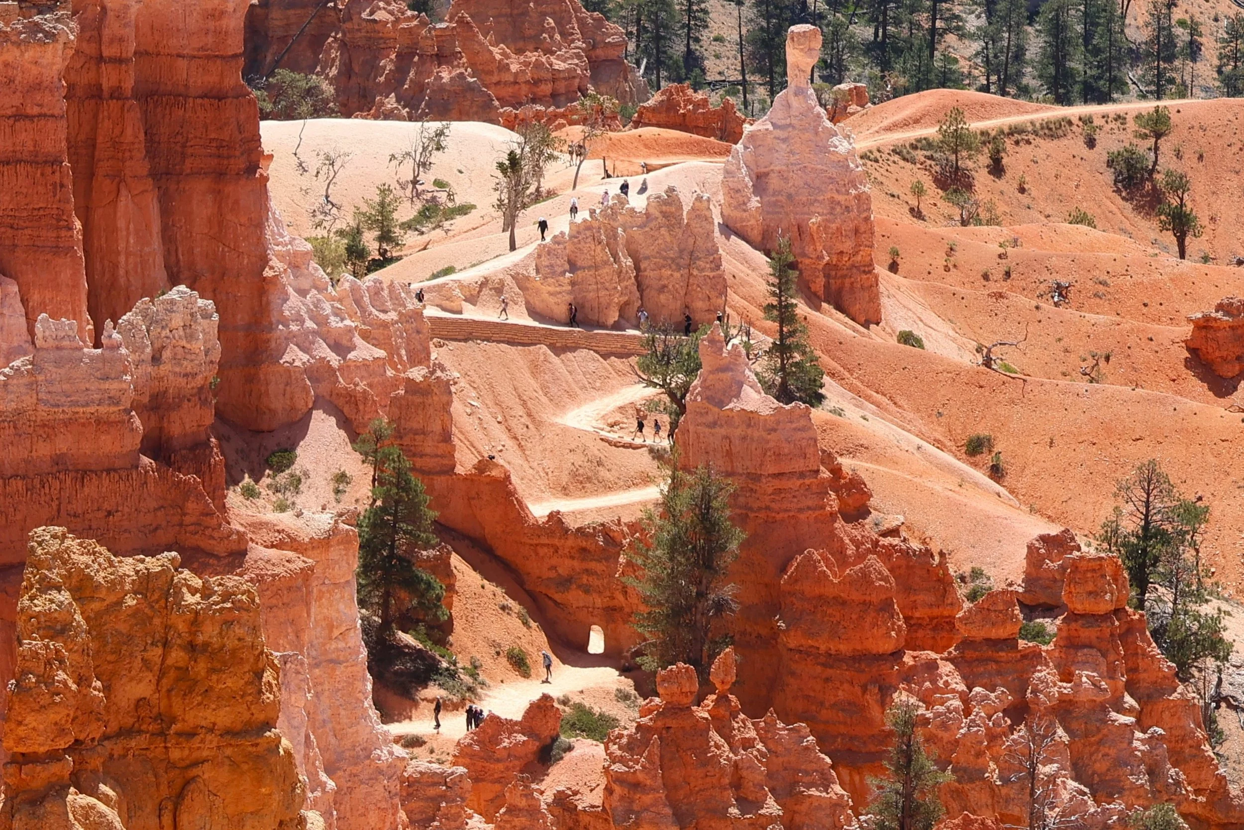
Mile Marker 7: Bryce Canyon City and the entrance to Bryce Canyon National Park

Bryce Canyon is home to the world's largest concentration of hoodoos—towering, brightly colored rock spires sculpted by millions of years of erosion. While Zion impresses visitors with its massive cliffs and towering canyon walls, Bryce feels like stepping into a whimsical fairy-tale landscape filled with intricate rock formations, vibrant colors, and otherworldly scenery unlike anywhere else on Earth.
Mile Marker 21: Cannonville BLM Visitor Center

Just 6 miles from Cannonville, Willis Creek Slot Canyon offers one of the most accessible and family-friendly slot canyon hikes in southern Utah. The adventure begins only a few steps from the parking area, where hikers follow the gentle flow of Willis Creek directly into a stunning, narrow canyon carved from soft sandstone.
Pro Tip: Check out the Cannonville BLM Visitor Center for maps, trail information, and current road conditions.
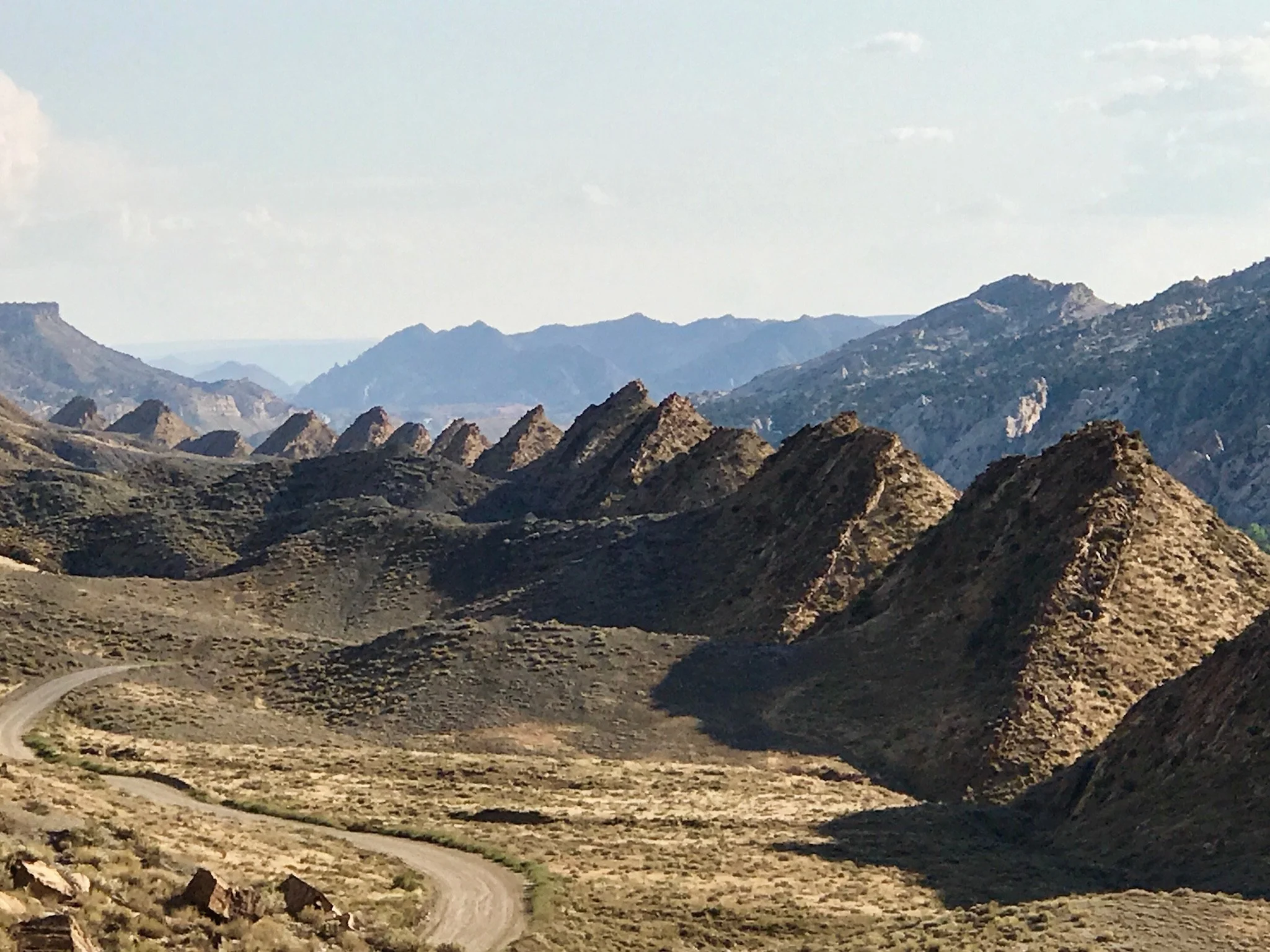
Feel adventurous? Take a scenic drive down Cottonwood Canyon Drive through the Grand Staircase-Escalante National Monument. It's 47 miles of dirt road with vistas of 160-million-year-old rock formations. The upheaval of the steeply tilted beds of the Tropic & Dakota formations makes you feel you are on the moon. Stop at the Cottonwood Narrows for a short hike. If the road is dry, you can drive a two-wheel drive vehicle. A few areas have ruts and bumps, but the road is usually in good condition. Below depicts the Upheaval called Cockscomb.
Mile Marker 60: Escalate, Utah
Welcome to the small, unique, charming ranching town of Escalate! Stop at Escalate Mercantile for lunch; pick up a Turkey and cranberry sandwich, Walnut Banana Bread, and a Blueberry Muffin. Nemo's Drive Thurs is a good choice for a burger, fries, and a Cookies and Cream milkshake!
Mile Marker 65: The Hole-In-The-Rock
Be sure to stop at the Head of the Rocks Overlook
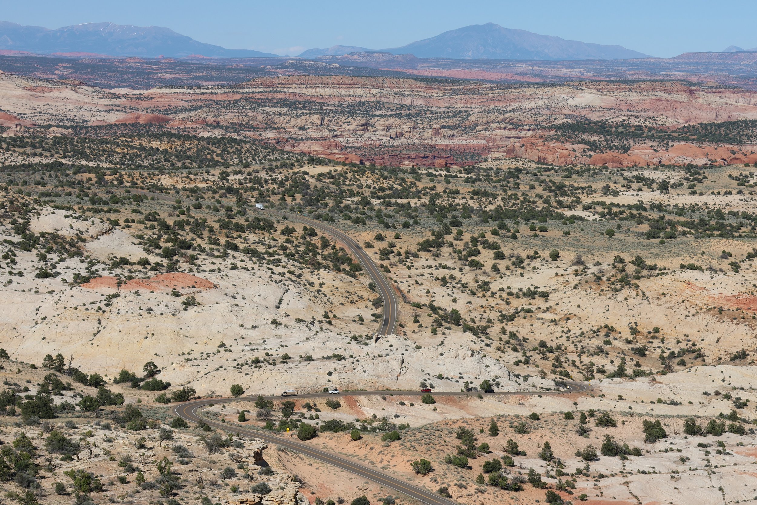
From this dramatic vantage point, you see sweeping panoramas of the Escalante Canyons, a vast maze of colorful slickrock, deep sandstone gorges, and winding canyons that stretch to the horizon. The layered landscape reveals the immense scale and rugged beauty of the Grand Staircase-Escalante region, making it a favorite stop for photographers and sightseers alike.
As you continue east, the road begins a dramatic descent toward the Escalante River, dropping down a steep 14% grade. The winding route provides ever-changing views of the surrounding canyon country. It offers a firsthand appreciation for the engineering and scenery that make Scenic Byway 12 one of America's most unforgettable drives.
Mile Marker 73: Kiva Koffeehouse
Mile Marker 73. Kiva Koffeehouse is a charming coffeehouse situated on a cliff with breathtaking views overlooking the canyon. It's an excellent destination for lunch, offering quiche, Spanish Tortilla, and cappuccinos, complete with pastries like tiramisu, cream puffs, or a cranberry scone, all while sitting on the outside porch.
Mile Marker 74: Natural Bridge Trailhead
You have reached the lowest point at 5,200' elevation at the Escalante River. This is also the trailhead to Natural Bridge, an impressive 130-foot-high arch with multiple ankle-deep river crossings, so bring your water shoes. The trail is 4.5 miles long, with level terrain and sections of deep sand.
Mile Marker 75: Lower Calf Creek Falls Hike

One of the most popular hikes along Scenic Byway 12 is the trek to Lower Calf Creek Falls, a spectacular 6-mile round-trip adventure that rewards hikers with a stunning 120-foot waterfall cascading over colorful, mineral-streaked sandstone cliffs into a refreshing pool below.
The well-marked trail follows Calf Creek through a beautiful desert canyon, crossing rocky sections, sandy stretches, and numerous shaded areas beneath cottonwood trees. Keep an eye out for ancient petroglyphs etched into the canyon walls near trail marker eight. The clear waters of Calf Creek are also home to brown trout, which can often be spotted swimming in the stream. Combining natural beauty, history, and a dramatic waterfall destination, Lower Calf Creek Falls is considered one of the must-do hikes in southern Utah.
Mile Marker 79: Welcome to "The Hogback."
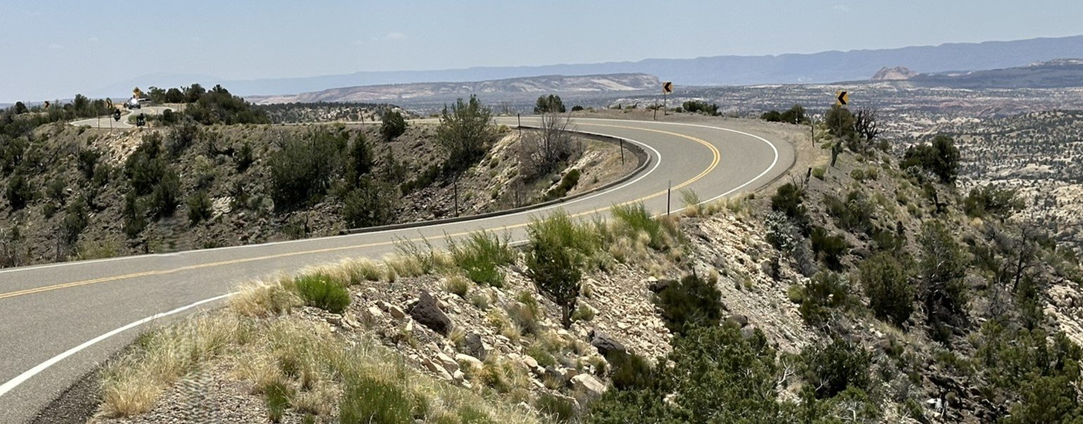
Welcome to The Hogback! The most famous section of Utah's Scenic Byway 12 and for some drivers, most intimidating section.
After climbing a steep 14% grade out of the Escalante River canyon, the road reaches a narrow ridgeline where the landscape suddenly opens in every direction. For approximately one mile, the highway follows the crest of the ridge, with dramatic drop-offs descending into colorful canyons on both sides. Fortunately, there are several pullouts and viewpoints along the way, allowing travelers to safely stop, take photos, and fully appreciate the incredible scenery.
Mile Marker 82: Hell’s Backbone Grill
In Boulder, stop to eat at Hell’s Backbone Grill. This farm-to-table restaurant enjoyed one of the highest Zagat ratings in Utah and was selected as a James Beard Award semifinalist in 2017, 2018, and 2019. Reservations may be required.
After the town of Boulder, the drive to Torrey, 37 miles, climbs and ascends the Boulder Mountain Pass at an elevation of 9,600'. From its elevation, the mountain offers panoramic views of aspen trees alongside the spectacular rock formations of Capitol Reef National Park and the Grand Staircase-Escalante National Monument. There are plenty of scenic viewpoints and overlooks.